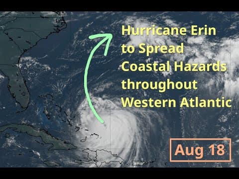
Hurricane Erin, currently a Category 4 storm, is moving northeast of the Turks and Caicos Islands, bringing heavy rains and strong winds. While it is expected to avoid direct land strikes, its expansive windfield will cause significant coastal impacts along the Eastern US, particularly in North Carolina, with high surf and potential flooding. Residents are advised to prepare for hazardous conditions as the storm approaches.
As of Monday, August 18th, we are closely monitoring Hurricane Erin, which is currently moving northeast of the Turks and Caicos Islands. This storm has already caused significant weather disturbances in the region, and its trajectory suggests that it will continue to impact coastal areas along the Eastern United States.
Hurricane Erin has been classified as a major hurricane, having reached its peak intensity as a Category 5 storm with maximum winds of 160 mph. As it passed north of the US Virgin Islands and Puerto Rico, it brought heavy rains and strong winds, leading to flash flooding and power outages in those areas. Fortunately, the storm has since weakened slightly and is now categorized as a Category 4 hurricane, with maximum winds of approximately 140 mph.
The hurricane's inner core has experienced disruptions due to eyewall replacement cycles and shear, which continues to affect its structure. Current reconnaissance data indicates a central pressure fluctuating between 935 and 937 millibars. The windfield of the storm is expanding, which will be a defining characteristic of Erin in the coming days.
The European model indicates that Erin is moving into a weakness between two steering ridges: one over the eastern US and another over the central Atlantic. This pattern suggests that the storm will make a northward turn, eventually moving northeast. The jet stream from the northwest will ensure that Erin avoids a direct strike on land areas, including the United States, the Bahamas, and Bermuda.
Despite avoiding direct land impacts, Erin's windfield is expected to grow larger than average for a hurricane in the Atlantic. As the storm moves northward, the tropical storm force windfield will expand, potentially affecting coastal North Carolina and Bermuda. The sheer size of the windfield means that coastal impacts will be felt even when the storm is hundreds of miles away from the shore.
One of the most significant threats posed by Hurricane Erin is the generation of high surf and ocean waves. The ECMWF model predicts wave heights exceeding 15 feet, with some areas experiencing waves over 21 feet. This will lead to severe impacts along the coastline, particularly in the Outer Banks of North Carolina, where mandatory evacuations have already been issued for some barrier islands.
The National Weather Service has issued high surf advisories and coastal flood advisories for the region. Forecasts indicate that wave heights of 15 to 20 feet are likely along the North Carolina coastline, leading to beach erosion and property over-washing in vulnerable areas. Additionally, rip currents and dangerous beach conditions are expected along the entire eastern seaboard.
As Hurricane Erin continues its path through the western Atlantic, it remains a major hurricane with significant coastal impacts anticipated along the Eastern US. While the storm is not expected to make direct landfall, the expansive windfield and generated ocean waves will create hazardous conditions for coastal communities. Residents along the eastern seaboard, particularly in North Carolina, should remain vigilant and prepare for potential disruptions as the storm approaches. Stay safe and informed as we continue to track Hurricane Erin's progress.