This week, a significant weather pattern shift will replace winter chills with record warmth across much of the U.S., followed by a powerful cold front bringing severe storms, heavy rain, ice, and snow. The Mississippi Valley faces a severe weather threat, the Midwest and Northeast will see ice storms and snow, and the Pacific Northwest will experience additional weather activity. Residents should prepare for rapid changes and potential impacts.
It's Monday, January 5th, 2025, and the weather across the United States is about to undergo a dramatic transformation. After a period of unusually warm temperatures, a powerful storm system is set to bring severe weather, ice storms, and snow to various regions. This article breaks down the upcoming weather events, their impacts, and what to expect in the days ahead.
Currently, much of the area east of the Rockies is experiencing a false spring, with temperatures soaring approximately 30 degrees above average for early January. This warm spell is especially pronounced in the South Central U.S., the Midwest, the Ohio Valley, the Southeast, and the East Coast.
These temperatures represent a significant departure from normal for this time of year and will persist throughout the week, with some areas warming even further on Wednesday and Thursday.
By Thursday and Friday, a sharp cold front will move through the region, creating a stark temperature gradient. For example, on Friday at 3:00 p.m., Cleveland could see temperatures near 60°F despite having four feet of snow on the ground, while Chicago will be around 41°F and Minneapolis near 28°F.
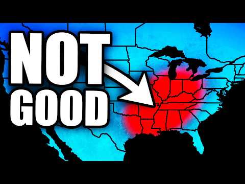
The collision of warm, moist air from the Gulf of Mexico with a powerful jet stream and an advancing low-pressure system is expected to trigger severe weather, particularly across the Mississippi Valley and parts of the Ohio Valley. The Storm Prediction Center has already issued a 15% risk area for severe storms on the day five outlook, which is notable for January.
Areas included in this risk zone are:
This system could produce damaging winds and possibly tornadoes, given the rare combination of warm temperatures, high dew points, and a sharp cold front in January.
Alongside the severe weather, several days of heavy rain are expected from the Deep South through the Ohio Valley and into the Midwest. This rain will fall on top of melting snow, raising concerns about flooding, especially where rain and thunderstorms train over the same areas.
Following the severe weather and rain, the backside of the storm system will bring significant snowfall to parts of the Upper Midwest and Great Lakes region.
This snow is expected despite the preceding warm spell, thanks to dynamic cooling—a process where the rapidly strengthening storm generates its own cold air supply, dropping temperatures quickly behind the low-pressure system.
In the short term, an ice storm is developing tonight into Tuesday morning, primarily affecting parts of Minnesota, Wisconsin, and Michigan. A narrow but potent corridor of freezing rain will create hazardous conditions as rain falls onto frozen ground, leading to ice accumulation.
This setup involves a "warm nose" of air at about 5,000 feet melting snow into rain, which then refreezes upon contact with the cold surface. While not expected to be crippling, ice accumulations over a quarter inch could cause power outages and major travel disruptions.
The ice threat will then move into the interior Northeast, bringing additional snow to Upstate New York, Vermont, New Hampshire, and Maine, though impacts there are expected to be less severe.
This week’s weather pattern is a classic example of winter’s volatility in the United States: a warm spell followed by a sharp cold front bringing severe weather, heavy rain, ice, and snow. Residents in affected areas should stay informed and prepare for rapidly changing conditions.
Daily updates and live streams will be provided as the situation evolves, especially concerning the severe weather risk and potential snowstorms. Make sure to stay tuned and have notifications enabled to receive the latest information.
Stay safe and be prepared for a dynamic week of weather ahead.