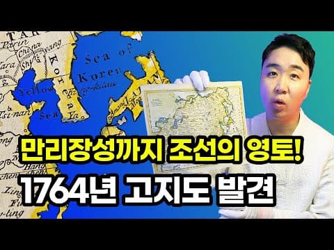
This blog post delves into a 1764 map created by Thomas Kitchin, highlighting the representation of Korea, China, and Japan, including the significance of the Sea of Korea and the historical borders of Korea as depicted in the map.
In this blog post, we will explore a fascinating historical map created by Thomas Kitchin in 1764, which provides insights into the geographical and political landscape of Korea, China, and Japan during that time. The map, purchased in London, reveals significant details about the representation of these countries and their borders.
The map clearly delineates the borders of Korea, extending from the Great Wall of China to parts of Manchuria and the area known as Gando. Notably, the East Sea is labeled as the "Sea of Korea," indicating that Western perceptions of this body of water recognized it as part of Korea's maritime territory. The map also features the city of Busan, referred to as "Ya," which raises questions about its origins and significance in the local dialect.
One intriguing aspect of the map is the spelling of Korea with a "K" instead of a "C." This change may reflect historical attempts by Japan to position Korea alphabetically after Japan, but the map suggests that this was not the initial intention. The representation of Korea as an independent entity is a significant point of discussion, especially considering the challenges faced when registering on foreign websites where Korea is often listed under "South Korea" or "Republic of Korea."
The map features a meticulously drawn Great Wall of China, which is represented with precision. The depiction aligns closely with modern understandings of the wall's structure and location, suggesting that the map is a reliable historical document. The Great Wall's endpoint is traditionally recognized at Shanhaiguan, which has been a point of contention regarding its historical significance and length.
Following the Great Wall, the map illustrates the border between Korea and China, starting from the Yalu River and extending to the Tumen River. This representation clarifies the historical territorial claims and disputes regarding the regions of Gando and Manchuria, which have been subjects of debate in modern times.
The map labels the East Sea as the "Sea of Korea," emphasizing its importance in the 18th century. The font size used for this designation indicates that it was considered a significant body of water, comparable to the Indian Ocean and the Pacific Ocean. This historical perspective reinforces the notion that the Sea of Korea was recognized as a vital maritime area by Western cartographers.
Within Korea, the map identifies two cities: King-kitau, which is a phonetic representation of Gyeonggi Province, and Busan, noted as "Ya." The historical context of Busan as a departure point for diplomatic missions to Japan adds depth to its significance during the Joseon Dynasty.
The map also references the Yellow Sea, labeled as such, which remains a commonly used name today. However, the designation of the East Sea is more contentious, as it varies based on national perspectives. The map's use of "Sea of Korea" suggests a preference for this term over the more widely recognized "Sea of Japan."
Turning to Japan, the map reveals various geographical names, including Kiu-sal for Kyushu and Funai for modern-day Oita. The historical context of these regions, particularly the Ryukyu Islands, is significant as they were independent until their annexation by Japan in 1879. This annexation parallels the experiences of Korea under Japanese rule, highlighting the broader themes of colonialism and cultural assimilation.
The map provides a glimpse into the borders of China during the 18th century, which were not as expansive as they are today. Key cities such as Peking (Beijing), Tsi-nan (Jinan), and Kay-fong (Kaifeng) are noted, each with its historical significance. The map illustrates the political and economic centers of the time, offering a snapshot of China's historical landscape.
The exploration of this 1764 map reveals much about the historical relationships and territorial claims of Korea, China, and Japan. It serves as a reminder of the complex history of these nations and the importance of understanding their past to appreciate their present. The next post will introduce a unique map from Japan, created in 1891, which promises to offer further insights into the historical narratives of these regions. Thank you for joining this exploration of history through cartography.