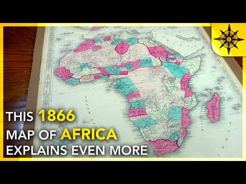
This blog post delves into the 1866 map of Africa, revealing the continent's rich history before colonialism. It highlights the diverse kingdoms, empires, and cultures that existed, illustrating how colonial borders disrupted these historical identities and continue to influence modern Africa.
Last year, I presented a map of Africa from 1935, which sparked discussions about the colonial impact on the continent. While it was insightful, many viewers pointed out its Eurocentric perspective. This prompted me to seek a different map that could better illustrate Africa's rich history before colonialism. During a trip to New Orleans, I discovered an 1866 map titled "Johnson's Africa," which offers a fascinating glimpse into the continent just before the Berlin Conference and the subsequent scramble for Africa.
The 1866 map is significant as it predates the formalization of colonial borders and reflects a time when Africa was home to various kingdoms, caliphates, and empires. This period was marked by a rich tapestry of cultures and governance systems that were often overlooked in favor of a Eurocentric narrative.
Starting in the northwestern corner of the continent, we find an area known as Barbar, named after the Berber people. Historically, this region was notorious for piracy, particularly the capture and trade of enslaved individuals. The Barbary slave trade was a major justification for European military campaigns in North Africa, with France being the first European power to establish a foothold by conquering Algeria.
These states, while tributary to the Ottoman Empire, exhibited a degree of autonomy that would later influence their post-colonial stability.
Moving into the interior, the map reveals vast expanses with fewer territorial demarcations. The Sahara, labeled as the Great Desert, was largely unexplored, and the map reflects this uncertainty. Below the Sahara, we find the Tibu people in northern Chad, whose presence has persisted since ancient times.
The region known as Sudan at the time encompassed a variety of smaller states, each with distinct ethnic groups and languages. The Fulani jihads significantly impacted this area, leading to the establishment of several Islamic states, such as the Msina Caliphate, which controlled vital trade routes.
As we approach the coast of Guinea, we encounter regions like Sinagambia, which includes modern-day Senegal and Gambia. This area was already engaged in trade with Europeans, evidenced by the presence of colonies like Sierra Leone and Liberia, the latter founded by freed American slaves.
Further south, the Ashanti Empire, under the rule of Quaka Duapan, resisted British colonial efforts through multiple conflicts known as the Anglo-Ashanti Wars. The Kingdom of Dahomey, ruled by King Gle, was also significant for its wealth derived from slave trading.
The map also contains intriguing geographical inaccuracies, such as the Kong Mountains and the Great Lake of Africa, which reflect the limited understanding of the continent at the time. These mythical features highlight the mystery surrounding Africa and the challenges faced by explorers.
In the Horn of Africa, we find Abbiscinia (Ethiopia), which was fragmented into various territories. The region of Somali was not yet recognized as a unified nation, reflecting the complex ethnic diversity that continues to affect modern Somalia.
The Swahili coast, particularly Zanzibar, was a hub for the East African slave trade, controlled by the Sultan of Oman. This historical context is crucial for understanding the dynamics of trade and colonization in the region.
The 1866 map of Africa serves as a powerful reminder of the continent's rich history before colonialism. It illustrates the complexity of African societies, their governance structures, and the cultural exchanges that existed long before European intervention. While the map was created from a Western perspective, it preserves the memory of the diverse peoples and places that shaped Africa's past. Understanding this history is essential for comprehending the ongoing challenges faced by African nations today.
In summary, the 1866 map not only provides a window into Africa's pre-colonial landscape but also invites us to reflect on the lasting impacts of colonialism and the importance of recognizing the continent's historical narratives.