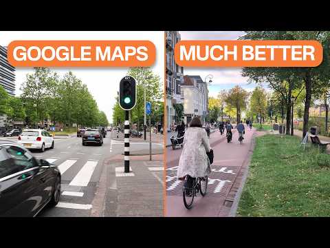
Google Maps, primarily designed for drivers in US cities, often fails to provide optimal cycling routes in Amsterdam. Dutch urban planning prioritizes efficient, safe, and enjoyable travel by separating car and bicycle traffic through distinct networks, a concept known as Ontvlechten. This approach contrasts with American cities where all streets are generally accessible to cars, highlighting the challenges of using driver-focused navigation apps for cycling in Dutch cities.
Navigating Amsterdam by bicycle is a unique experience that differs significantly from cycling in many other cities, especially those in the United States. While Google Maps is a popular navigation tool worldwide, it often falls short in providing the best cycling routes in Amsterdam. This article explores why Google Maps doesn't work very well for cyclists in Amsterdam and how this reflects fundamental differences in urban design between Dutch and American cities.
When using Google Maps for bicycle directions in Amsterdam, the app tends to send cyclists along certain roads that are not necessarily the most pleasant or efficient. For example, Google Maps might direct you along a busy or less scenic road, even though there is a much nicer and safer route available nearby. Although these directions will get you to your destination, they are rarely the best or most enjoyable way to cycle.
The core issue lies in the fact that Google Maps is fundamentally an application designed for drivers. While it includes bicycle-specific features, the navigation system is primarily developed by teams based in the United States, where the focus is on car travel.
In most US cities, cars are allowed on nearly every street, and it is uncommon to find streets accessible only to bicycles but not cars. American traffic engineers often praise the street grid system because it allows drivers to reroute easily if a street is blocked or congested. This approach assumes that:
Consequently, apps like Google Maps prioritize real-time navigation updates to reroute drivers to faster streets, reflecting the priority of moving cars efficiently.
For cyclists in North American cities, this means navigating an environment designed primarily to move as many cars as possible. Therefore, cycling directions often mirror driving directions, minus highways.
In contrast, Amsterdam and many other Dutch cities prioritize moving people rather than cars. The transportation system emphasizes space-efficient modes such as walking, cycling, and public transit. Moreover, Dutch urban planning recognizes that cities should be healthy, safe, lively, and enjoyable places to live.
Cars are loud, polluting, dangerous, and occupy significant space. To create livable cities, Amsterdam carefully manages where cars can go and actively reduces car traffic within the city.
One of the key tools Amsterdam uses to manage car traffic is the Hofnet, or main network map, which designates roads intended for through car traffic. Within this network, some roads are labeled as Plusnet, where car traffic is prioritized. This network is designed to route most car traffic away from residential neighborhoods and local shopping streets, minimizing the negative impact of cars on residents.
Alongside the car network, Amsterdam has separate networks prioritizing cycling, public transit, and walking. Notably, there is very little overlap between the Plusnet for cars and the Plusnet for cycling. This separation is intentional and crucial for safety.
The number one danger for cyclists is motor vehicles. To protect cyclists, cities build protected bike lanes separated from car traffic by curbs, parked cars, or physical barriers. The Netherlands takes this concept further through a principle called Ontvlechten, which means unbundling or disentangling.
Ontvlechten involves designing routes so that the paths taken by drivers are fundamentally separated from those taken by cyclists. This means that when cycling in the Netherlands, you are very likely to be on roads with very little car traffic because most cars have been routed elsewhere.
This separation is not just about infrastructure but about the overall design of the transportation network. The cycling network is prioritized and distinct from the car network, enhancing safety and enjoyment for cyclists.
Google Maps navigation is optimized for drivers and assumes a street network where cars can go almost everywhere. It does not fully account for the Dutch approach of separating car and bicycle routes. As a result, Google Maps often suggests routes that follow roads designed for cars rather than the safer, more pleasant cycling routes.
The cycling routes prioritized in Amsterdam are a subset of the overall bicycle infrastructure, focusing on routes where cycling is given precedence over other forms of transportation. Google Maps does not yet fully integrate this nuanced network into its routing algorithms.
The reason Google Maps does not provide the best cycling directions in Amsterdam is deeply rooted in the fundamental differences in urban design philosophy between the Netherlands and the United States. While American cities prioritize moving cars efficiently, Dutch cities prioritize moving people safely and enjoyably, with a strong emphasis on cycling and walking.
Amsterdam's approach of disentangling car and bicycle routes through networks like the Hofnet and the concept of Ontvlechten creates a safer and more pleasant cycling environment. Until navigation apps like Google Maps better incorporate these principles, cyclists in Amsterdam may find it beneficial to rely on local knowledge or specialized cycling maps rather than defaulting to driver-focused navigation tools.
Understanding these differences not only helps cyclists navigate Amsterdam more effectively but also offers valuable insights into how urban planning can shape transportation experiences and city life.