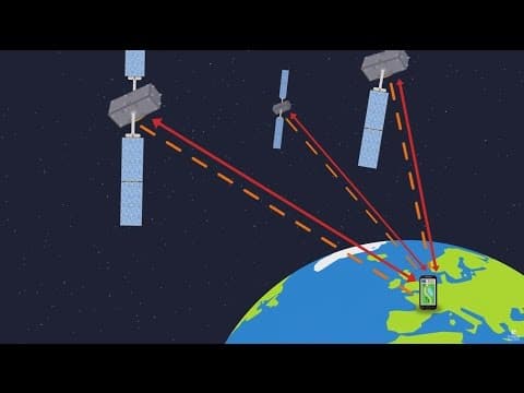
Galileo is a European satellite navigation system consisting of 24 satellites that provide precise location data globally. It operates through trilateration, utilizing signals from satellites to determine distances and synchronize time, ensuring accurate positioning for users like hikers and travelers.
Galileo is a sophisticated satellite navigation system developed by the European Union, consisting of a constellation of 24 satellites orbiting approximately 23,000 kilometers above the Earth. This system is designed to provide accurate positioning information to users around the globe.
The 24 satellites are evenly distributed across three different orbital planes, with eight satellites in each orbit. Additionally, there are up to six reserve satellites in orbit to ensure continuous service in case any of the primary satellites fail. This configuration guarantees that any location on Earth is consistently covered by at least four satellites at any given time, which is essential for accurate location determination.
To illustrate how Galileo functions, let’s consider the example of Lucas, a hiker equipped with a Galileo receiver in his smartphone. It is important to note that the system can support up to a billion users simultaneously without any degradation in performance.
The satellites continuously emit signals that carry crucial information, including the time of emission. When Lucas's phone receives these signals, it records the time of reception and decodes the emission time from the signals. By calculating the time it took for the signals to travel from the satellites to his phone, and knowing that these signals travel at the speed of light, the phone can determine the distance to each satellite. This calculation is based on the fundamental formula: distance = time × speed.
Using the distances calculated from at least three satellites, Lucas's phone can determine his position through a process known as trilateration. However, to enhance accuracy, a fourth satellite is necessary. This is because the system relies on precise time measurements facilitated by atomic clocks onboard the satellites and in the receivers. While the satellite clocks are perfectly synchronized, the clock in Lucas's phone may have a slight discrepancy, potentially up to one second.
The fourth satellite helps synchronize all the clocks, ensuring that the timing is accurate to within ten billionths of a second. This level of precision is critical; a timing error of just three billionths of a second can result in a positioning error of one meter.
Galileo is not just about satellites; it also includes a robust ground segment consisting of two control centers and 16 monitoring stations distributed worldwide. These ground stations are equipped with antennas capable of receiving and transmitting signals. The control centers are responsible for ensuring the system operates smoothly and for calculating the precise orbits of the 24 Galileo satellites relative to the Earth.
Every 100 minutes, the ground stations communicate with the satellites to update their orbital positions. This information is vital for receivers like Lucas's phone to accurately determine their location on Earth.
In summary, Galileo represents a significant advancement in satellite navigation technology. By leveraging a network of satellites and ground stations, it provides precise location data that is essential for various applications, from hiking to global navigation. As users like Lucas benefit from this technology, the underlying complexity of the system ensures that they can always find their way, no matter where they are in the world.